

Review finds issues with signage, sightlines and intersection design
A traffic review of the intersection where the fatal collision between the Humboldt Broncos bus and a semi-trailer collided occurred in April has been completed, and all 13 recommendations will be implemented by the provincial government.
The traffic engineering review looked at the geometric, collision, traffic and human factor characteristics of the intersection of highways 35 and 335 in an effort to identify any improvements that may reduce those risks. It was commissioned in response to April’s crash, and was conducted by Regina’s McElhanney Consulting Services.
While the study found that collisions were infrequent at the site, there have been two collilsions with fatal outcomes since 1990. In addition to the Broncos bus crash, a 1997 collision between a pickup truck and a semi killed six people.
The consultants observed the intersection three times over two days in a variety of conditions. They saw three vehicles roll through the stop sign and one vehicle fail to yield to another.
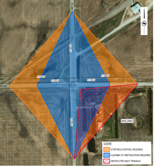
They found that signage at the intersection is not adequate, the shoulder is too narrow and the sight line between Highway 35 north and Highway 335 West is obscured by trees.
In the collision involving the Broncos bus and the semi, the bus was travelling north and the semi west.
Following the collision, the Ministry of Highways removed the trees on its right of way. However, a stand of trees remains on private property.
“The removal of trees within the (Ministry of Highways) right-of-way only marginally improves the sight triangle,” the report said.
“The trees still remain on the private property in the southeast corner …. the trees would need to be removed in order to achieve the sight triangle.”
The sight triangle is the area between the two intersecting roads approaching an intersection where visibility is important.
The report also took issue with the way the west approach to the intersection looks. It found that while the intersection itself is controlled by a stop sign on Highway 335, for a significant distance in either direction, it is not.
“As a result, motorists may become complacent and asume tht Hihgway 335 is uncontroleld at all intersections. This facttor, in conmbinsation with other issues … increases the risk that a motorist will overlook the control and fail to stop.”
The report also found that the road alignment, horizon, trees and power poles can lead to tunnel vision and that the alignment of highway 335 can lead to glare at sunrise and sunset. The April 8 crash occurred about three and a half hours before sunset.
The road design “could focus motorist’s attention to the centre of Highway 335 further west which may result in overlooking Hwy 35 and the stop sign,” the report said.
“The illusion is observed to be even more pronounced during wet or sun glare conditions.”
To better help drivers approaching the intersection on Highway 335 from the west, the report recommended installing rumble strips, painting stop ahead and stop indicators on the pavement and increasing the size of the stop ahead and stop signs.
It also recommended clearing the trees on the southeast corner of the intersection to improve visibility between the two highways.
Other recommendations included simplifying the intersection for drivers, moving signs to improve sightlines and ensuring the signs themselves are installed on break-away bases.
Those recommendations called for a simplification of the arrangement of overhead power lines to cut down on driver distraction, the relocation of the roadside memorial and removal of that gravel road, the realignment of the nearby grain elevator access road and a widening of the shoulders.
The government said it will implement all of the recommendations, but since the issue is before the courts, will not comment further.
The sign-related improvements, stop ahead pavement markers, installation of breakaway bases for signs and painting of solid centre lines on both highways are set for completion in Winter 2018-19. The installation of rumble strips is scheduled for the summer, while a timeline has yet to be established for realigning power lines, removing the trees on private property, removing the gravel road, moving the roadside memorial and realigning the grain elevator access.
The shoulders will be widened the next time that stretch of road is due for paving.
Most of the costs are estimated to be in the tens of thousands, except for the rumble strips, estimated at $300,000, as new, thicker pavement needs to be installed, the widening, which is estimated at $400,000 per km and the realignment of the grain elevator access, estimated at $250,000.
The cost of tree removal is unknown as it will have to be negotiated with the private landowner. The costs of realigning the power lines and constructing a new roadside memorial access road are also unknown at this time.