by Fred Payton
It must have seemed like a good idea at the time when, at the Nov. 30, 1965 meeting of City Council, they approved a recommendation from the Centennial Committee to impose eighteen neighbourhood names in the City of Prince Albert. Let’s face it, although there were a few names which could be considered to be imaginative (Goshen and Hazeldell, for instance), neighbourhood names such as East Hill and West Hill, West Flat and East Flat are pretty mundane.
With the exception of three years during which I lived on the East Flat in a neighbourhood commonly called Midtown, most of my life has been lived in four different houses on what has always been known, to me and to others, as the West Hill. So, it came as some surprise to me when I discovered that this motion had been passed by City Council. It would have designated the area of the city in which I lived at that time, and in which I currently live, as Buena Vista. Moreover, one of the West Hill houses in which I lived would have been part of the Brentwood neighbourhood, while the neighbourhood in which I lived in Midtown would have been known as Riverside.
As mentioned, these neighbourhood designations had been recommended by the Centennial Committee of the City of Prince Albert as part of the celebratory plans for Prince Albert’s 100th anniversary, held in 1966. Council approved the item at the November 30th, 1965 meeting. So what has happened to these names, and why am I not currently living in the Buena Vista neighbourhood?
Some of the names, including Westview, and Crescent Heights, have lasted as neighbourhood names to this day. Others, such as Hazeldell and Goshen, already existed and have remained as part of the nomenclature for areas of the city. But names such as Pinedale, Parkhill, Westmount, and Homewood are names that you will have never seen on any recent city maps.
The response to Council’s November 1965 decision was immediate, and tended to be negative. In the December 3rd edition of the Prince Albert Daily Herald, it was made clear that the print media was vehemently opposed to the changes. An editorial entitled “Will Get New Names” noted the existence of some of the proposed names, such as Normandy Park and Victory Place, but ridiculed the idea of anyone having to address a letter to, for example, 159 – Buena Vista. The editorial was, perhaps, a little unsound, but it certainly left no doubt as to the stance of the newspaper.
At the following City Council meeting, a letter was received from Eric Langland of the Prince Albert Real Estate Board in which it was held that the name changes would “confuse the issue rather than accomplish the aim for which it was intended”. It was suggested that the Board approved in principle the naming of areas, but believed that the manner in which the areas were to be divided resulted in areas which were too small. They should be “larger and encompass greater numbers of people in each neighbourhood.”
It was pointed out that the East Flat would be divided into six neighbourhoods, far too many to reflect the neighbourhood’s size. The letter also pointed out that the names of areas should more closely reflect Prince Albert’s history and area. “…while Buena Vista, Mount Pleasant, and Westmount may be picturesque and suitable for some cities or countries, they reflect nothing of Prince Albert’s history, culture, or of our North Saskatchewan setting.”
Alderman Jim Sanderson weighed in on the issue, indicating that he had tried to determine if the city had the right to change existing designated names of the various neighbourhood areas and that he had discovered that it did not. “The city has no power to pass any such bylaw to change existing names of the areas. It can only be a matter of custom, and that’s all.”
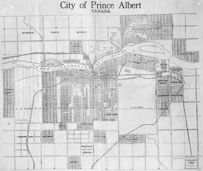
In response, Alderman Marion Sherman indicated that the majority of the names chosen had been taken from a 1912 Prince Albert survey map. A copy of the map to which she alluded does include Park Hill, Hazeldell, Westmount, and Mount Pleasant. Also appearing on the map is the name Crescent-Wood, in an area similar to the location of the current Crescent Heights. However, many of the names included on the 1912 map, such as The Bronx, Riverdale Park, Princeton, and Ruskin Place, are not included in the 1965 place names.
Some names, such as Bestland, Bouckfield Gardens, and Kensington Heights are land locations which are not included even within today’s city limits. All are within the R.M. of Prince Albert, with Bestland and Bouckfield Gardens south of the city, and Kensington Heights west of the city towards the Lily Plain district.
The discussion concluded when Mayor Barsky suggested that whether change was to be made by council resolution or by bylaw, the suggestion to adopt the new names of neighbourhoods would require that the city “get the feelings of the people”. Obviously, he felt, more discussion was required, and he moved that the entire matter be laid on the table.
A matter tabled at Council must have been dealt with at a later date, but so far my research has been unsuccessful in determining when this occurred. The fact that I still live on the West Hill and not Buena Vista would suggest that when the matter was dealt with, the decision taken was definitely not in the affirmative.


